Mountain Park Trail Map
A great way to see the flora and fauna of Pueblo Mountain Park is to take a hike along one of the trails. There are over eight miles of trails in the park, open to foot and horse traffic. Mountain Bike traffic is permitted on Carhart Trail, only. San Isabel National Forest can be accessed through Pueblo Mountain Park, offering many more miles of trails.
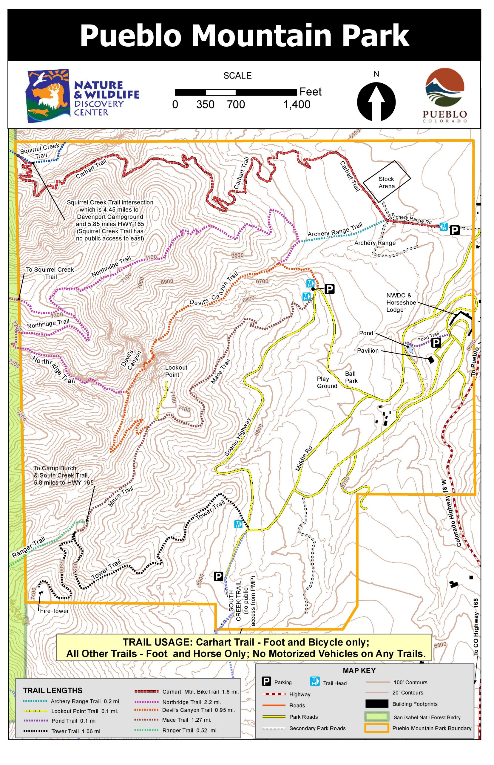
Devil’s Canyon Trail: Accessed from the trailhead just up the road from the ballpark, this trail is the most heavily used trail in the park. The trail travels along a seasonal drainage called Devil’s Dribble. Much of the trail is shaded, making it a perfect summer afternoon hike. You can access Northridge Trail and Mace Trail from Devil’s Canyon Trail.
Mace Trail: The trailhead is just up the road from the Devil’s Canyon Trailhead. It climbs through most of the park’s terrestrial ecosystems. You can access Tower Trail and Lookout Point via Mace Trail.
Tower Trail: The Tower Trailhead is at the southern end of the Scenic Highway, the park’s upper road. You can access Camp Burch and USFS Trail #1321 (South Creek) via this trail, as well as loop into the Mace Trail. The fire tower is the high point of the park, at 7,400 ft elevation.
Northridge Trail: The park’s longest trail can be accessed at the Devil’s Canyon Trailhead. This trail loops into the Mace Trail and the upper part of the Devil’s Canyon drainage. Northridge Trail provides access to USFS Trail #1384 (Squirrel Creek).
CarhartTrail: The park’s newest trail is 1.8 miles, one way. Carhart Trail meanders through the northern edge of the park and connects to the historic Squirrel Creek Trail, which leads to Davenport Trail, both within San Isabel National Forest. This varied and adventurous trail is perfect for hikers, trail runners, and mountain bikers! No horse traffic on Carhart Trail, please.